Ottoman-Habsburg Wars (1521-1791)
Images from eight wars fought between 1570 and 1718
View of Djerba island, 1560 (Djerba, Madanīn, Tunisia) 33°48ʹ00ʺN 10°54ʹ00ʺE
1560 or laterEtching with engraving; printed on paper; mounted on paper (Mount Type A); gilt edge, right | Scale: 1:250,000 approx | RCIN 721008
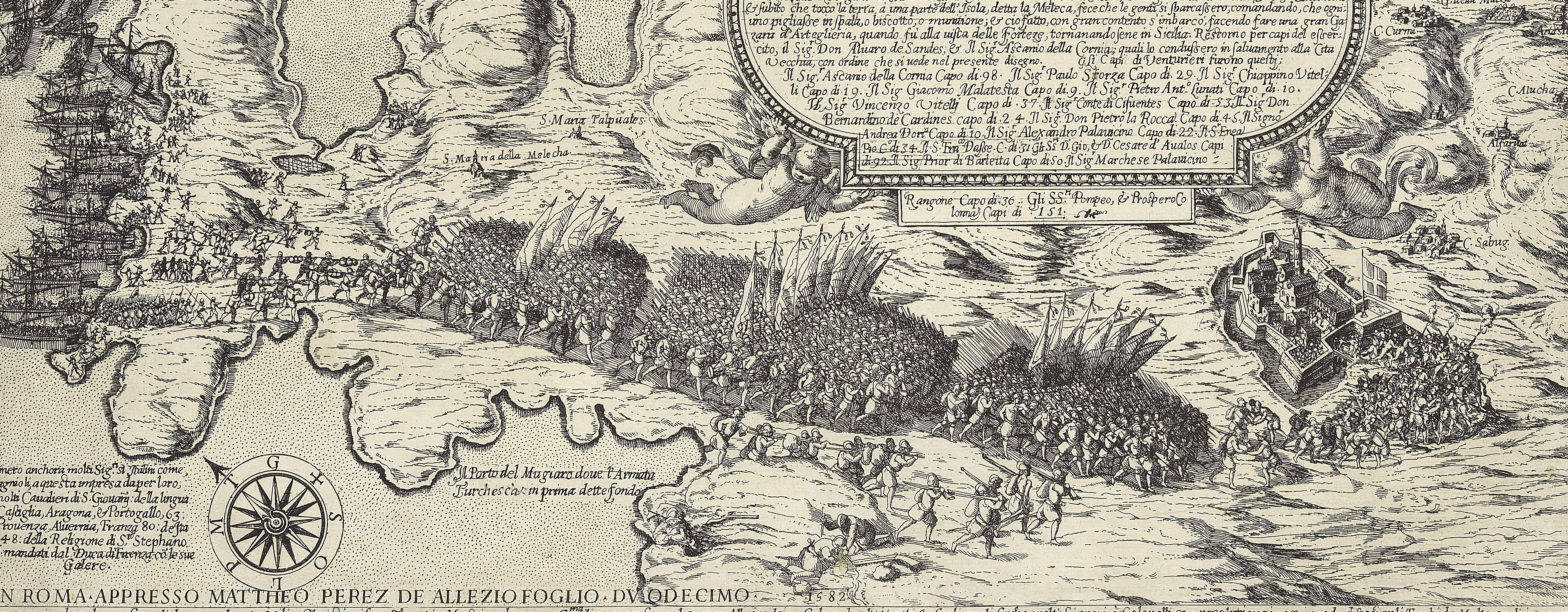
A high oblique view of the Holy League troops on Djerba in March to May 1560 and the Turkish fleet confronting the Christian fleet off the north coast of Tunisia in May 1560. The Ottoman Empire (1500-1606): Conflicts in the Mediterranean (1532-1565). Oriented with north to top (cardinal points).
The Turkish position on Djerba, an island off the south-east coast of Tunisia, was taken by surprise by the fleet and troops of the Holy League, led by Philip I of Spain (Spain, Genoa, Papal States, Knights of Malta), commanded by Giovanni Andrea Doria (1539-1606), in March 1560. The Christian army established a garrison and fort ashore. The Turkish fleet, commanded by Admiral Pyale Pasha (c.1515-1578), was warned of the event and sailed to the island in May causing the troops and fleet of the Holy League to flee, losing some thirty galleys during a battle lasting a few hours and abandoning many of the soldiers in the onshore garrison.
This view, although dated in the old catalogue to 1535, shows the events of 1560. Part of the Christian fleet at the northern end of the island appears to be taking (or landing) troops who are being ferried across the shallow lagoon (three ‘passi’ or paces deep’). The troops who were left behind took refuge in the fort, shown at the northern end of the island, which had been constructed during the expedition (as noted in the title of the view). Some of the Christian galleys appear to be fleeing from the Turkish fleet; flags with crossed keys represent the Papal States; the double-headed eagle the Holy Roman Empire (Spain); the cross the Genoese and the Duchy of Savoy; the Maltese cross - the Knights of Malta; two of the galleys appear to be sporting the symbol of the Medici (in this case Cosimo I): six balls in a circle. The position of the first camp, near some fortified wells, are shown to the north-west and troop positions are shown elsewhere on the island.
Anonymous (cartographer)
Subject(s)
Navy-TurkeyArmy-Ottoman EmpireWatermark: Two arrows, crossed
Condition: creased; one fold line in the mount; the original inner ink framing line appears to have been drawn to the wrong size and has had to be redrawn; cropped to edge of detail; the pattern of surface dirt on the recto indicates that this print was, at some time, left in a pile with overlying items long enough to have become dirty
Scale: 1:250,000 approx. Scale bar: 300 Miglia [ = 222 mm]
29.9 x 43.5 cm (sheet, image and neatline)
37.0 x 52.4 cm (mount)
Printed title:
Disigno dell' Isola de Gerbi con le seche che la difendeno dall' inondatione del mare, et il sito della fortezza fatta da Christiani alla defesa della quala ui è restato / cinq millia ualorosi soldati, e' buona prouisione di vituaglie e monitione che con l'aiuto di Dio bastara à diffenderla dall' Insulti de l armata Turchescha. [along bottom of view, within neatline]
Annotation:
George III heading: Zerbi Island on the N. coast of Africa. 1535.
Other annotations: (Recto) none. (Verso) [top left, on mount and print, red pencil:] 1/5-[?].
George III catalogue entry:
Zerbi Disegno dell’Isola de Gerbi con le seche che la difendeno dall’inondatione del Mare et il sito della Fortezza fatta da Christiani alla defesa della quala ui e restato 5000 Soldati a diffenderla dall’insulti de l’Armata Turchescha, 1535.
Subject(s)
Djerba, Madanīn, Tunisia (33°48ʹ00ʺN 10°54ʹ00ʺE)
Bibliographic reference(s)
M. McDonald, The Print Collection of Cassiano dal Pozzo. Part II, Architecture, Topography and Military Maps, 3 vols, London 2019, cat. no. 2642
F.B. Salvadori, Carte, piante e stampe storiche delle raccolte Lafreriane della Bibliotea nazionale di Firenze, Indici e Cataloghi Nuova Serie XI, Rome 1980 p.105, no. 139
R.V. Tooley, ‘Maps in Italian atlases of the sixteenth century, being a comparative list of the Italian maps issued by Lafreri, Forlani, Duchetti, Bertelli and others, found in atlases’, Imago Mundi III, 1939, pp. 12-47, no. 244
R. Mackenny, Sixteenth century Europe: expansion and conflict, Basingstoke 1993, p. 259
Page revisions
25 May 2024
Current version


