Contemporary maps of 10 sixteenth-century wars
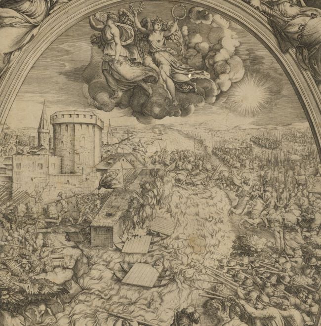
View of the Battle of Moncontour, 1569 (Poitou-Charentes, France) 46°52ʹ51ʺN 00°01ʹ11ʺW
1569 or laterEtching; printed on paper; laid down on paper; mounted on paper (Mount Type B); gilt edges left, bottom and right | 20.3 x 28.6 cm (image and sheet) | RCIN 721051
A middle/high oblique view of the Battle of Moncontour, fought on 3 October 1569 between the French Catholics, commanded by Henry Duke of Anjou (later Henry III; 19 September 1551-2 August 1589) and the French Huguenot army, commanded by Admiral Gaspard de Coligny (16 February 1519-24 August 1572) resulting in a Catholic victory. French Wars of Religion (1562-1598); Third War (1568-1570). Oriented with north (Tramontana) to top.
The Royalist, Catholic army, bolstered by Swiss mercenaries inflicted a crushing defeat on the Huguenots; Coligny was wounded. This view, centred on Moncontour, with Tours top right, and Poitiers bottom left, shows the slaughter and flight of the Huguenots (‘ogonotti’) and the marsh ‘doue sono morti iluterani’.
Anonymous (cartographer)
Subject(s)
Comte de Coligny Gaspard de Chatillon, Admiral of France (1519-72)Watermark: Indistinct device in circle; backing paper: none; mount: crown, cropped
Condition: very worn with some loss of image, repaired by being laid down on paper before being mounted; brown discolouration from the adhesive which was used to attach the backing paper; impressions from the mounts of items which were kept above or below this view in a former sequence are present on the recto and verso
20.3 x 28.6 cm (image and sheet)
cropped (platemark)
40.2 x 54.5 cm (mount)
Printed title:
No title [High oblique view of the Battle of Moncontour, 3 October 1569]
Annotations:
George III heading: Battle of Moncontour on the 3d of October 1568 [sic] in which Admiral Coligni was defeated.
Other annotations: (Recto) [left, black pencil, erased old heading notes]; [top right, red pencil:] 1569; [bottom right, black pencil:] 1569; [top left on mount, underneath K.Mil number, black pencil, erased:] 59. (Verso) [top left, on mount, red pencil:] 1/46; [top left, on mount, black pencil, erased:] I [or II]/47; [top right, on mount, black pencil, erased, underlined but indistinct: a place name?].
George III catalogue entry:
Moncontour Representation of the Battle of Moncontour on the 3.d of Oct.r 1568 [sic] in which Admiral Coligni was defeated.
Subject(s)
Poitou-Charentes, France (46°52ʹ51ʺN 00°01ʹ11ʺW)
Bibliographic reference(s)
M. McDonald, The Print Collection of Cassiano dal Pozzo. Part II, Architecture, Topography and Military Maps, 3 vols, London 2019, cat. no. 2699
Page revisions
25 May 2024
Current version


