Contemporary maps of 10 sixteenth-century wars
View of Boulogne, 1549 (Boulogne, Nord-Pas-de-Calais, France) 50°43'00"N 01°37'00"E
c.1602Etching with engraving; printed on paper; not mounted; gilt edges to right | 28.9 x 33.3 cm (image and neatline) | RCIN 721017
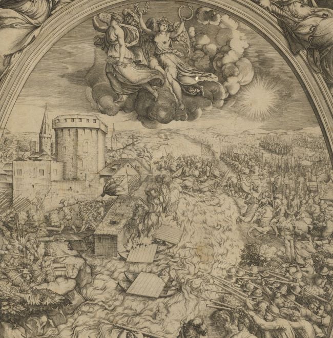
A middle oblique view of the French assault on English-held Boulogne, resulting in the withdrawal from the town by Henry VIII’s forces in 1550. English wars with France and Scotland (1542-1550). Oriented with north-east to top.
Boulogne had been captured by Henry VIII in 1544; he then spent £1,300,000 of the proceeds of the dissolution of the monasteries in fortifying the town. This view shows, left, the old Roman 100ft-high tower (known as the ‘Old Man’), flying the English standard, which had been fortified by Henry to guard the maritime approach to the town while, to the right of the tower, is a new fort which was, according to this print, called ‘paradise’ by the English but which appears actually to have been called the ‘Young Man’. The purpose of this new fort was to provide secure communications between the Old Man and the Low Town, ‘La Bassa Bologna’, which was fortified by walls and a citadel which guarded the banks of the River Liane. These fortifications were also strengthened by Henry VIII. The new French fortifications, on the hills on the south of the river Liane, were begun in 1545 and are seen here marked as ‘Fortezza de Fransesi’ and ‘Ardelot’ (Fort de Châtillon and Fort d’Outreau). The fortification shown in the background, top right, may be Boulemberg (now Mont Lambert), built as an additional outpost by the English in 1546.
The English tenancy of Boulogne is signalled by the standards which bear Henry’s coat of arms while the French forces and forts are identified by the fleur-de-lys. The French infantry are mustered in the pike squares, typical of the period. The length of the pikes (anything from twelve to eighteen feet, or 3.6-5.5 metres long) compared with the size of the man, is well demonstrated in this view.
What appears to be the original issue of this print, undated and without van Schoel’s imprint, or any author statement, is listed as number 140 in Tooley (1939). It was commonly included in Lafreri-type atlases but was presumably more rare in circulation at the time that Cassiano dal Pozzo was collecting – nearly a 100 years later, hence the presence of the later reprint, rather than the original in this collection.
Hendrik van Schoel (d. 1622) (printmaker) [inside neatline, bottom left:] Henricus Van Schoel. excudit.
Subject(s)
Army-FranceArmy-EnglandArmy-France-InfantryWatermark: Anchor in circle surmounted by six-pointed star [see Woodward nos 158-176]
Condition: one fold; creased; some foxing on both sides. Verso: black ink along bottom left edge of print
28.9 x 33.3 cm (image and neatline)
29.5 x 43.9 cm (platemark)
38.7 x 52.8 cm (sheet)
Printed title:
BOLOGNA IN FRANCIA [top centre, in banner]
Additional text:
[bottom left:] Questo e' il uero ritratto di Bologna in francia occupato / dal Re' d'inghilterra, et al presente' assediato dal christianissimo / Re' di francia nella quale' li fransesi ui hanno fatto una fortezza / contra ditta citta come' dentro il disegno si po uedere'
Annotations:
George III heading: Boulogne besieged by the French in 1549.
Other annotations: (Recto) [top left, faint red pencil:] 1549 besieged by the French. (Verso) [top left, black pencil:] I/18; [top, left of centre, red pencil: 1/15; [top right, black pencil, erased:] Boulogne; [bottom right, black pencil:] Naval pf.
George III catalogue entry:
Boulogne A Representation of the Siege of Boulogne by the French in 1549. H. van Schoel excudit.
Subject(s)
Boulogne, Nord-Pas-de-Calais, France (50°43'00"N 01°37'00"E)
Bibliographic reference(s)
H. M. Colvin (ed), The history of the King’s Works, vol.III, Part I, London 1975, pp. 383-393
M. McDonald, The Print Collection of Cassiano dal Pozzo. Part II, Architecture, Topography and Military Maps, 3 vols, London 2019, cat. no. 2649
P. Collinson, The sixteenth century 1485-1603, Oxford 2002, p.195
R.V. Tooley, ‘Maps in Italian atlases of the sixteenth century, being a comparative list of the Italian maps issued by Lafreri, Forlani, Duchetti, Bertelli and others, found in atlases’, Imago Mundi III, 1939, pp. 12-47, no. 140
Page revisions
25 May 2024
Current version


