Contemporary maps of 10 sixteenth-century wars
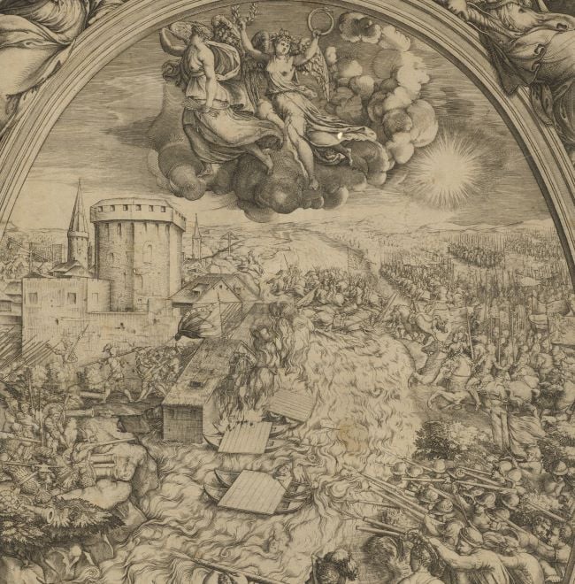
View of the siege of Calais, 1558 (Calais, Nord-Pas-de-Calais, France) 50°57ʹ07ʺN 01°51ʹ22ʺE)
first published 1568-1585; re-published 1602Etching with engraving; printed on paper; not mounted but with the double ink framing lines of Mount Type A; gilt to right edge | 34.2 x 46.7 cm (image, neatline and platemark) | RCIN 721024
A middle/high oblique view of the siege of the English town of Calais, commanded by Thomas Wentworth, 2nd Baron Wentworth (1525-13 January 1584) between 1 and 7 January 1558 by the French, commanded by Francis, Duke of Guise (17 February 1519-24 February 1563), resulting in a French victory. The last Valois-Habsburg War (1547-1559). Oriented with north (not named) to top; west (Ponente), east (Levante) and south (Mezzodi) are named.
The dates of 1 and 7 January for the beginning and end of the siege are taken from correspondence between Wentworth and Mary, and between Michiel Surian, Venetian Ambassador with King Philip, to the Doge and Senate. Writing on 2 January, Wentworth records the arrival of the French and, on 8 January, Surian writes (no.1129.) that ‘Today, at noon, news arrived of the entry into Calais of the French …’, while, on 8 January, a certain Jean Perdrix, townsman of Calais, … declared as follows: On 7 January, at 2 o’clock after midnight, the French entered the castle of Calais by a breach … At about 6 o’clock, it was learnt that … the town had been surrendered.’
Calais had been an English possession since it was captured by Edward III in 1387; it had been strongly fortified and maintained but, under Mary I (reigned 19 July 1553-17 November 1558), it was allowed to fall into neglect. The buildings of Calais are drawn in perspective. The fortification at the end of the promontory – the Rysbank – is the Rysbank Tower. The large tower in the foreground of Calais may be the Day Watch Tower, built in 1488-1489; at the top of the view the old fort at the NW point of Calais is Calais Castle. Calais, garrisoned by the English under Lord Thomas Wentworth, was attacked by Guise between 2 and 7 January 1558. Wentworth capitulated, losing England's last foothold in France.
Newnham Bridge (lettered ‘N’ in the view) is shown at the centre of the left edge; it controlled the causeway across the marshes to the west of Calais and was of great strategic importance. Its sluices could be used to dam the Hammes river, thereby flooding the country around the town. Writing to Mary on 4 January, Lord Grey reported that ‘The French have won Newnham Bridge, and thereby entered all the low country and the marches between this and Calais. Also Ruisbank, whereby they are masters of that haven.’
The principal roads and the watercourses are represented in a similar way so that the main road to Gravelines (top right) and the other roads with which it connects, look more like a fast flowing rivers.
When Claudio Duchetti died in 1585, some of his stock, including copperplates went to Giovanni Orlandi who had a print shop in the Pasquino and usually added the imprint ‘Ioannes Orlandi formis romae 1602’, as in this print of Calais.
A state of this print, lacking the imprint of Duchetti and Orlandi, is in BnF, GEDD-1140(82RES). For other collections with this earlier version, see Tooley (1939) no.152 and Salvadori (1980) no.266. An example of this later version is at BL Maps C.7.c.4.13.
Claudio Duchetti (d. 1585) (printmaker) [bottom right, inside neatline, within text panel:] Romæ Claudij Duchetti formis
Giovanni Orlandi (active 1590-1646) (publisher) [inserted above Duchetti's imprint:] Ioannes Orlandi formis romæ 1602
Subject(s)
Army-Duke of GuiseWatermark: Anchor in circle surmounted by a six-pointed star [see Woodward nos 158-76]
Condition: no fold lines; slight creases; the sheet appears to have been cropped top and bottom, and the top right corner is cut off; a pressure mark is present along the bottom of the mount from a mounted item which was placed above/below this item in a former collection
34.2 x 46.7 cm (image, neatline and platemark)
39.6 x 51.6 cm (sheet)
Printed title:
Il uero ritratto de Cales preso à Inglesi del Re Cristianissimo l'Anno / · M · D · LVIII ·[bottom left, in rectangular panel]
Additional text:
[bottom left, below title, in title panel, a key, A-H:] le lettere maiuscole te dimostrano l'luochi piu importanti. [bottom right, in rectangular panel, a continuation of the key, I, K-P.]
Annotations:
George III heading: Calais 1558.
Other annotations: (Recto) [top, right of centre, black pencil, erased and illegible]. (Verso) [top left, red pencil:] 1/23; [top left, black pencil, erased and very faint:] I/[36]; [top right, black pencil, erased:] Calais.
George III catalogue entry:
Calais Il vero Ritratto de Cales preso a Inglesi del Re Cristianissimo l’anno 1558. I. Orlandi formis 1602. C. Duchetti formis.
Subject(s)
Calais, Nord-Pas-de-Calais, France (50°57ʹ07ʺN 01°51ʹ22ʺE))
Bibliographic reference(s)
D. Woodward, 'The Italian map trade, 1480-1650', in History of Cartography, vol.III, Part 1, Chicago 2007, pp. 773-798
H.M. Colvin (ed), The history of the King's Works, London 1975, vol.I, pp. 423- 450; vol.III, Part I, 1485-1660, pp. 337-363
M. McDonald, The Print Collection of Cassiano dal Pozzo. Part II, Architecture, Topography and Military Maps, 3 vols, London 2019, cat. no. 2657
'Mary: January 1558', Calendar of State Papers Foreign, Mary: 1553-1558 (1861), pp. 354-363. Date accessed: 09 June 2014
'Venice: January 1558, 1-10', Calendar of State Papers Relating to English Affairs in the Archives of Venice, Volume 6: 1555-1558 (1877), pp. 1407-1421. Date accessed: 09 June 2014
'Spain: January 1558, 1-15', Calendar of State Papers, Spain, Volume 13: 1554-1558 (1954), pp. 321-333. Date accessed: 09 June 2014
Page revisions
25 May 2024
Current version


