Contemporary maps of 10 sixteenth-century wars
View of Maina, Cape Matapan and Pórto Kagio, 1570 (Mani Peninsula or Khersonisos Máni, Peloponnese, Greece) 36°35ʹ00ʺN 22°25ʹ00ʺE; (Ákra Taínaron, Peloponnese, Greece) 36°23ʹ11ʺ 22°28ʹ58ʺE; (Pórto Ka
published 1570Etching; printed on paper; mounted on paper (Mount Type A); gilt eges top and right | Scale: 1:993 approx. | RCIN 721053
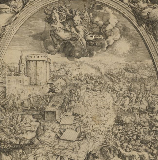
A high oblique view/map of the siege of the newly constructed Ottoman fortress near Porto Kagios by the natives of the peninsular, the Maniots, assisted by the Venetians resulting in the Turkish surrender. Fourth Ottoman-Venetian War (1570-1573). Oriented with north to top.
The dimensions of the fortress, probably given in Venetian paces, are written on top of the walls. The fortress, then situated at Porto Quaglio in the Morea, had been built in order to disrupt the Venetian naval route to Crete and Cyprus. Seven ships, inside the port, are firing on the fortress; four other cannon are firing at the northern walls. The Christian infantry forces have scaled the walls of the fort and have engaged the Turks in battle.
Giovanni Francesco Camocio (active 1560-72) (printer and publisher) [top right, at bottom of cartouche:] IN [reverse ‘N’] VENETIA. [reverse ‘N’] / Apresso Gio. Franc.o Camocio. / i570
Subject(s)
Army-TurkeyNavy-Venetian RepublicWatermark: Map: crown with fleur-de-lys above; mount: partly cropped: the letter 'F' over triple mount in a shield with sharp corners and points on the sides [see Woodward nos 332-333]
Condition: one fold line to mount; some abrasion to the surface of the map; ink smudging; brown spots on the mount; impressions from the mounts of items which were kept above/below this map in a former sequence are present on the recto and verso
Scale: 1:993 approx. Scale-bar: Passa uinti de Venetia. [35mm = 20]; [this scale probably applies to the depiction of the fortress]
29.8 x 22.1 cm (image and sheet)
cropped (platemark)
51.5 x 40.5 cm (mount)
Printed title:
Fortezza nouamente fatta da Turchi / detta Turchartogli Olimicras, che in / greco dice fortezza de Mani et in / turchescho Monige al porto delle / Quaglie, et Mayna al' Capo Mat / tapan nella Morea presa dal' / CLmo Cap.o de Colfo Quirinicó / l'armata de Candia alli [there follows a space with a dash in the middle, perhaps for the insertion of the day of the month] / di Iulio. i570. et poi spiniata. / Qual fortezza era per longezza / passa. 7i et per largezza passa / 36. Venetiani. [bottom right, in rectangular panel with scrolled top]
Annotations:
George III heading: Maina July 1570.
Other annotations: (Recto) [top right, black pencil:] 1570. (Verso) [right, on mount, red pencil:] 1/48. [top, on mount, black pencil, erased:] Turchartogli Olimicras; [top right, black pencil:] I/50; [bottom left, black pencil, erased:] I/50.
George III catalogue entry:
Maina Fortezza di Mayna al’ Capo Matapan nella Morea presa dal Cap.o de Colfo Quirini co’ l’armata de Candia alli … di Lulio 1570; apresso G.F. Camotio. 1570.
Subject(s)
Mani Peninsula or Khersonisos Máni, Peloponnese, Greece )36°35ʹ00ʺN 22°25ʹ00ʺE)
Ákra Taínaron, Peloponnese, Greece (36°23ʹ11ʺ 22°28ʹ58ʺE)
Pórto Kagio or Pórto Káyio, Peloponnese, Greece (36°25ʹ41ʺN 22°29'07"E)
Bibliographic reference(s)
M. McDonald, The Print Collection of Cassiano dal Pozzo. Part II, Architecture, Topography and Military Maps, 3 vols, London 2019, cat. no. 2701
Page revisions
25 May 2024
Current version


