The wars of 1735–9, 1768–74 and 1787–92
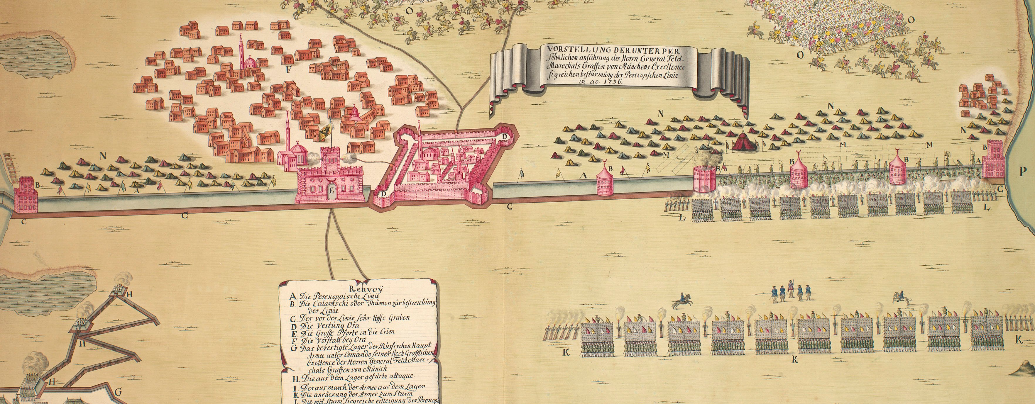
Perekop, 1736 (Perekop, Avtonoma Respublika Krym, Ukraine) 46°09'41"N 33°41'35"E
1736 or laterPencil, pen, ink and watercolour on paper; some pricking through | Scale: 1:37,000 approx. | RCIN 728010
The London Gazette (no.7520 June 29-3 July 1736) carries a description of the aftermath of the attack shown on this map: ‘Count Golowkin, the Czarina's Minister here, has had advice, that the Day after General Munich forced the Lines of the Tartars before Perecop, the Garrison of that Place surrendered itself, and that the said General found therein about 2500 Janissaries, and above 80 Pieces of Brass Cannon. That he had left a sufficient Number of Troops in Perecop, detached a strong body towards the Boristhenes, and with the Gross of his Army was marching towards Bachisarai, the capital City of the Crimea and the late Residence of the Cham.’ General Munnich apparently blew up and ‘erased’ the castle of Perekop and all the strong Line, as well as the castle of Kinburn on the Kinburn Peninsula, on his return to that place in July 1736 (London Gazette no. 7551 October 16-October 19 1736).
Additional text: [bottom, left of centre, in a cartouche representing a trompe l'oeil torn sheet of paper, a key, A-I, K-Q, to the significant military and topographical features:] Renvoÿ.
Condition: one fold line; one small hole, right border, top; one small tear, right.
OC de Marin (active 1736-41) (cartographer) [bottom right, outside border:] Ingenieur Lieut: O.C. de Marin
Subject(s)
Army-TurkeyArmy-RussiaWatermark: Fleur-de-lys in shield below crown, the whole suspending an elongated ‘4’; countermark IV
Mark, stamped: 258
Condition: one fold line; one small hole, right border, top; one small tear, right
Scale: 1:37,000 approx. Scale not stated.
47.3 x 68.2 cm (neatline)
49.2 x 69.2 cm (image)
51.7 x 71.7 cm (sheet)
Printed title:
VORSTELLUNG DER UNTER PER / söhnlichen anführung des Herrn General Feld- / Marechals Graffen von Münchens Excellence / sigreichen bestürmung der Perecopschen Linie / in ao. 1736.
Additional text:
Renvoÿ. [bottom, left of centre, in a cartouche representing a trompe l'oeil torn sheet of paper, a key, A-I, K-Q, to the significant military and topographical features]
Annotations:
George III heading: The Lines of Perecop forced by the Russians in June 1736.
Other annotations: (Recto) none. (Verso) [bottom centre, red pencil:] 6/76; [top right, black pencil, erased:] 1736; [top, right of centre, black pencil, erased and mostly illegible: Perecop?].
George III catalogue entry:
Perecop Vorstellung der unter persohnlichen anfuhrung des Graffen von Munchen sigreichen besturmung der Perecopschen Linie in anno 1736: vom Ing.r Lieut. O.C. de Marin. drawn. [The same entry appears under the heading Lines.]
Subject(s)
Perekop, Avtonoma Respublika Krym, Ukraine (46°09'41"N 33°41'35"E)
Page revisions
23 May 2024
Current version


