Contemporary maps of 10 sixteenth-century wars
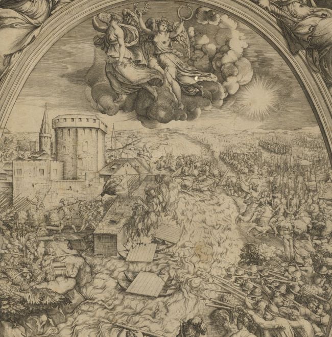
View of the siege of Guînes, 1558 (Guînes, Nord-Pas-de-Calais, France) 50°52ʹ01ʺN 01°52ʹ12ʺE
published 1558Etching with engraving; printed on paper; mounted on paper (Mount Type A); gilt edges left, bottom, and right | 33.6 x 44.5 cm (image and sheet) | RCIN 721026
A middle oblique view of the siege and capture by the French, commanded by Francis, Duke of Guise (17 February 1519-24 February 1563) ofthe English stronghold of Guînes in January 1558. The last Valois-Habsburg War (1547-1559). Oriented with north to top.
Guines lies about 10 km (6.2 miles) south of Calais. It was the main outpost of English rule in the Marches of Calais throughout the Tudor period and there was constant, considerable expenditure on its fortifications. The arrangement of the fortifications, as shown in this view, is not consistent with a number of contemporary plans which are preserved in the British Library. These show that the castle was to the north-east of the town whereas here, the castle is shown to the south. Further, the outlines of the fortified walls do not resemble those of the contemporary plans (in particular, see BL Cotton MS. Augustus I, ii 71, ca 1550).
The scene portrays the encampments of ‘Mons. Destree’ – Jean 1er Duc d’Estrées (1486-1571), who had been at Calais the previous weeks; ‘Mons di Nemours’, probably Jacques of Savoy, 2nd Duke of Nemours (1531-1585), a supporter of Guise; Mons. il Marescalco Strozzi – Piero Strozzi, Marshal of France (c.1510-21 June 1558); Mons. il Marchese d’Albeuf, probably René of Guise, Marquis d'Elbeuf (14 August 1536-14 December 1566); and others. Standards bearing the emblems of the participating factions are placed at the front of the encampments. Three of the castle’s bastions have been breached and the Spanish forces are making a determined assault but are being strongly repelled by the garrison, while smoke and flames billow from the town. The fact that Guines held out for a week before capitulating was apparently a result of the bravery and valour of the garrison troops rather than the strength of the fortifications.
The marshy terrain of the surrounding topography is shown to good effect and Hammes Castle can be seen to the north-west. Being ‘environed on all sides with fens and marsh grounds’ it was not easy to approach. It was the last English stronghold to fall after its Captain, Lord Dudley, hearing of the capitulation of Guînes, quietly left with his small garrison, travelling secretly over the marshes into Flanders.
This view was a stock component of Lafreri atlases in the second half of the sixteenth century. An example of this view, without the imprint ‘Formis Romæ. ¥ · Ð · LVIII ·’, is in the BnF (GE D-13981). The text of the title and alphabetical key appears to have been pasted onto the title panel in the BnF example, but the area in the bottom border of the panel is blank where the imprint should be.
Anonymous (cartographer)
Subject(s)
Army-Duke of GuiseArmy-FranceArmy-SpainWatermark: Pascal lamb in circle [similar to Woodward no. 50]
Condition: three fold lines; cropped to edge of image; small tear to mount, top right; the acid from the ink of the outer framing line has eaten through the bottom left corner of the frame; bottom left corner of mount cut off. Verso: surface dirt; brown stains
33.6 x 44.5 cm (image and sheet)
41.5 x 54.7 cm (mount)
Printed title:
GVINES [top centre, in a banner]
Printed title:
RITRATTO DELLA FORTEZZA / di Ghines, presa per forza de englesi dallo / eßercito del Re Christianißimo [centre right, in a panel]
Additional text:
[right centre, below title, in title panel:] Per le lettere maiuscole potrai cognoscere le / cose piu importante. [Followed by a key, A-I, K-T, V, X-Z.]
Annotations:
George III heading: Guines taken by the Duke of Guise 1558.
Other annotations: (Recto) [left edge, black pencil:] taken by the Duke of Guise 1558 [top centre, black pencil, erased and partly illegible:] [?] 1558; [bottom right, black pencil:] 1558. (Verso) [top left, red pencil:] 1/24; [top left, black pencil, erased:] I/[27].
George III catalogue entry:
Guines Ritratto della Fortezza di Ghines presa per forza de Englesi dallo Essercito del Re Christianissimo, 1558.
Subject(s)
Guînes, Nord-Pas-de-Calais, France (50°52ʹ01ʺN 01°52ʹ12ʺE)
Bibliographic reference(s)
F.B. Salvadori, Carte, piante e stampe storiche delle raccolte Lafreriane della Bibliotea nazionale di Firenze, Indici e Cataloghi Nuova Serie XI, Rome 1980, no. 296
M. McDonald, The Print Collection of Cassiano dal Pozzo. Part II, Architecture, Topography and Military Maps, 3 vols, London 2019, cat. no. 2659
R.V. Tooley, ‘Maps in Italian atlases of the sixteenth century, being a comparative list of the Italian maps issued by Lafreri, Forlani, Duchetti, Bertelli and others, found in atlases’, Imago Mundi III, 1939, pp. 12-47, no. 293
H. M. Colvin (ed), The history of the King’s works, vol. III, Part I, London 1975, pp. 363-373
Page revisions
25 May 2024
Current version


