Contemporary maps of 10 sixteenth-century wars
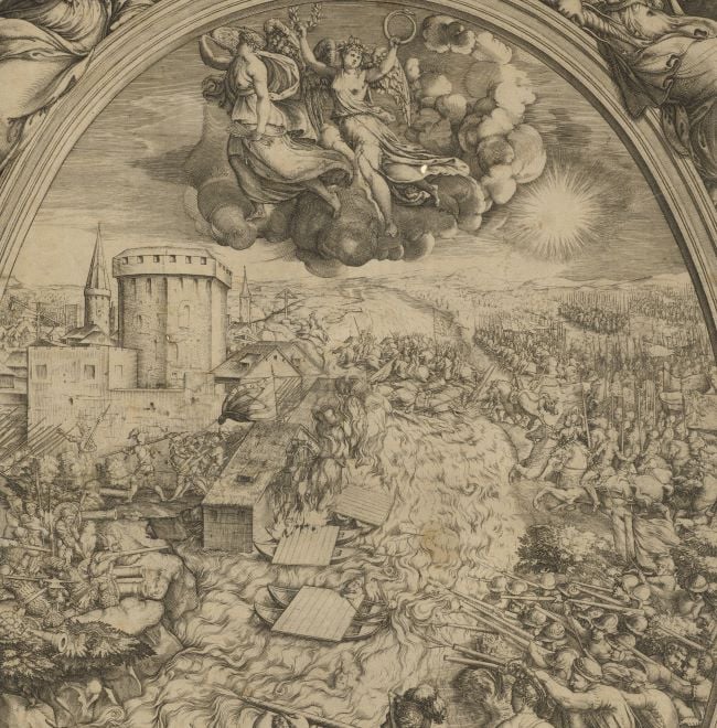
View of the siege of Thionville, 1558 (Thionville, Lorraine, France) 49°22ʹ00ʺN 06°10ʹ00ʺE
1558; re-published 1602Engraving with etching; printed on paper; mounted on paper (Mount Type A) | 30.5 x 41.9 cm (image and sheet) | RCIN 721027
A medium oblique view of the siege by the French, commanded by Francis, Duke of Guise (17 February 1519-24 February 1563) of the Spanish army at Thionville in May and June resulting in the fall of the town on 22 June 1558. The last Valois-Habsburg War (1547-1559). Oriented with north-west to top (but north is indicated: SEPTENTRIO).
The siege was to have been begun by the Governor of Metz, Vieilleville, but he was requested to wait until Guise arrived on 4 June. Also present was the chief of artillery, D’Estrées and General Pietro Strozzi (c.1510-21 June 1558), Superintendent of the Papal army who was, on 20 June, ‘mortally wounded by an arquebuse-shot, at the very side of Guise, who was talking to him with a hand on his shoulder.’. Strozzi, without taking care to protect himself, had apparently angrily given a command to assemble six culverins together with the cannons in order to batter the town into ruins when he was shot. He died half an hour later.
The semi-circle of canals to the south of the town could be flooded by opening the sluices gates, shown in this view. Although this map does not appear in the Lafreri atlases listed by Tooley in 1939, it is present in another Lafreri-type atlas, i.e. an ‘Italian atlas assembled to order’ [IATO] which is preserved in the Royal Archaeological Society of the Land van Waas (Sint-Niklaas, Belgium).
Nicolaus Beatrizet (active 1540-72) (engraver and publisher) [outside text panel, bottom right:] Nicolaus / Beatrizet / Lotoringus / Incidit: et / formis
Giovanni Orlandi (active 1590-1646) (publisher) [in text panel, bottom right:] Ioannes Orlādi formis 1602
Subject(s)
Army-FranceArmy-SpainArmy-Duke of GuiseWatermark: None visible
Condition: flat; cropped to edge of image; no gilt edges
30.5 x 41.9 cm (image and sheet)
41.3 x 54.8 cm (mount)
Printed title:
Vera Thiumuillae effigies sum, reddita docti / Artificis manibus, quam modo Galli tenes. / Dum tamen expugnor, cecidit fortisimus ille / Stroza Italûm Petrus gloria summa ducum. / Anno domini · M · D · LViij · / Die 22 · Junij. [bottom left, in a rectangular panel. Note that the 'i' in 'Galli' appears to have been engraved over an ‘e’ as a correction]
Annotations:
George III heading: Thionville taken by the Duke of Guise 22 June 1558.
Other annotations: (Recto) [top centre, black pencil:] taken by the Duke of Guise; [bottom right, black pencil:] 1558. (Verso) [in red pencil:] 1/26.
George III catalogue entry:
Thionville Representation of the taking of Thionville by the Duke of Guise 22.d June 1558; by N. Beatrizet. I. Orlandi formis, 1602.
Subject(s)
Thionville, Lorraine, France (49°22ʹ00ʺN 06°10ʹ00ʺE)
Bibliographic reference(s)
'Venice: July 1558', Calendar of State Papers Relating to English Affairs in the Archives of Venice, Volume 6: 1555-1558 (1877), pp. 1512-1524. Date accessed: 10 June 2014: Giovanni Michiel, Venetian Ambassador in France, to the Doge and Senate, original depatch date 11 June 1558; Venetian Archives. 1240: 'On the 4th instant the Duke de Guise arrived under Thionville'
N. De Wolf and P. De Maeyer, 'Italian composite atlases and a Belgian undescribed copy', The Cartographic Journal vol.4, no.4, 2008, pp. 296-303
F. Guizot (R. Black transl.), A popular history of France from the earliest times, vol.1, Boston [1880], unpaged
N. Ten Hove (with notes and observations by Sir R. Clayton), Memoirs of the House of Medici, vol. II, London 1797, pp. 260-262
M. McDonald, The Print Collection of Cassiano dal Pozzo. Part II, Architecture, Topography and Military Maps, 3 vols, London 2019, cat. no. 2660
EXHIBITED London, The British Museum (1993) ‘The Paper Museum of Cassiano dal Pozzo’, exhibit no.159; illustrated on p.256 of the accompanying catalogue
Page revisions
23 May 2024
Current version


