War of the Polish Succession (1733-8)
The Rhine and Moselle rivers and parts of Italy
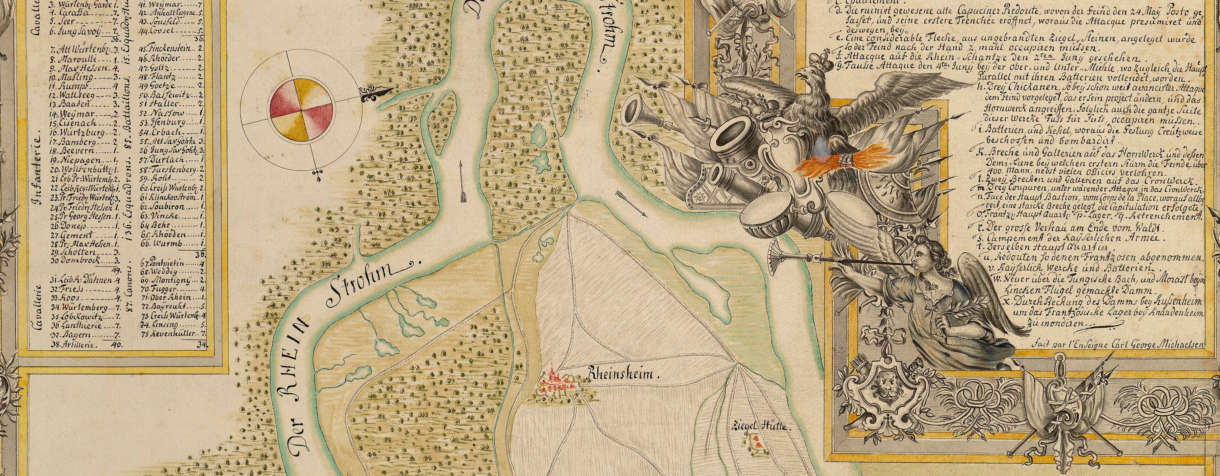
Map of the Moselle and Rhine, Bacharach and Worms, 1735 (Bacharach, Rhineland-Palatinate, Germany) 50°03ʹ26ʺN 07°46ʹ10ʺE; (Worms, Rhineland-Palatinate, Germany) 49°38'08"N 08°21'35"E
1735 or laterPencil, pen, ink and watercolour on two sheets of paper, joined; laid down on coarse linen; edged with pink silk; a brass ring for hanging, top right; a brass ring missing, top centre, and top left; ink linen tie, right | Scale: 1:55,000 approx. | RCIN 727075
The map extends from Bad Kreuznach in the south-west to Mainz in the north-east. The title states that the coverage of the Rhine extends to Worms; in fact, the map stops just north of Worms at Hernsheim (Herrnsheim 49°39ʹ13ʺN 08°19ʹ55ʺE).
The order of battle gives the following General Officers of the First Line: Generals the Prince of Bavaria, Prince George [of Hesse], Mörner, Seehr; Lieutenant-Generals Diemar, La Lippe, Sholten, Amtor, Potzlatzky; Major-Generals Misseroni, Creiger, Chancloss, Borck, Dombruck, Kaas, Stein.
The General Officers of the Second Line are Generals the Prince of Bavaria, La Marck, Mörner, Seehr; Lieutenant-Generals Bretlach, Frise, Wallis, Pompieten, Potzlatzky; Major-Generals Nisseroni, Rutoffsky, Niepagen, Prince Waldeck, Wurmbrand, Stein.
The abbreviation ‘Mas: Ord:’ which Schultz uses in the headings of the General Officers in the order of battle, probably stands for Master of the Ordnance, which is a direct translation of ‘Feldzeugmeister’ which term, in the eighteenth century, appears to have applied to the rank of General of Infantry.
Additional text: [bottom right, above title, in mainly rectangular panel:] ORDER of BATTLE of the Imperial Army under the Com[m]and of Count Seckendorff as at BINGEN when on His MARCH towards y.e MOSELL in 1735 [bottom right, below title, in title panel, a key, 1-26, to the encampments, lines and movements of the Imperial and French armies from 31 August to 3 October:] The EXPLANATION [bottom right, in title panel, a key to the colours used to distinguish the encamped Imperial and French infantry and cavalry, the Imperial artillery, and the French posts:] The Marks of the INCAMPMENTS &C.
Condition: two fold lines; pronounced surface dirt along left edge; spots and patches of brown discolouration. Verso: induced discolouration; brown marks; surface dirt; top, right of right fold line, a light square-shaped patch, perhaps marking the former presence of a library label (too small to be Cumberland's cipher label); heavy surface dirt along left edge.
Anonymous (cartographer)
Subject(s)
Army-ImperialArmy-AustriaArmy-FranceWatermark: None visible
Condition: two fold lines; pronounced surface dirt along left edge; spots and patches of brown discolouration. Verso: induced discolouration; brown marks; surface dirt; top, right of right fold line, a light square-shaped patch, perhaps marking the former presence of a library label (too small to be Cumberland's cipher label); heavy surface dirt along left edge.
Scale: 1:55,000 approx. Scale bar: A Scale of one German League [103 mm = ].
65.0 x 93.4 cm (image and sheet)
63.4 x 90.2 cm (neatline)
Manuscript title:
A PLAN of the COURSE of the RHINE from WORMS to Bacarach with the Imperial and French INCAMPMENTS before & after Count Seckendorff’s / MARCH towards the MOSELL in the Year 1735. [bottom right, in mainly rectangular panel]
Additional text:
ORDER of BATTLE of the Imperial Army under the Com[m]and of Count Seckendorff as at BINGEN when on His MARCH towards y.e MOSELL in 1735 [bottom right, above title, in mainly rectangular panel] The EXPLANATION [bottom right, below title, in title panel, a key, 1-26, to the encampments, lines and movements of the Imperial and French armies from 31 August to 3 October] The Marks of the INCAMPMENTS &C. [bottom right, in title panel, a key to the colours used to distinguish the encamped Imperial and French infantry and cavalry, the Imperial artillery, and the French posts]
Annotations:
George III heading: [bottom right, black pencil:] Rhine 1735 Military.
Other annotations: (Recto) none. (Verso) [top right, black pencil:]1735; [top right, red pencil:] 1735; [bottom, left of right fold line, white label with ‘ROYAL LIBRARY’ and a crown printed in red, with, in blue biro in a modern hand:] VII 75 Rhine.
K. Mil. dummy sheet
Title, ink: A drawn Plan of the course of the Rhine from Worms to Bacarach, with the Imperial and French / Incampments before and after Count Seckendorffs March towards the Mosell in the year 1735 / 2 sheets / A Roll … [black pencil:] 5 Table 2.d [At foot of page, old heading:] Encampment on the Rhine in 1735 [black pencil, in a modern hand:] Big: sep seq.
Watermark: BUDGEN & WILMOTT 1810.
Size: 47.0 x 32.6 cm (sheet).George III catalogue entry:
Rhine A drawn Plan of the Course of the Rhine from Worms to Bacarach, with the Imperial and French Encampments before and after the Count Seckendorff’s March towards the Moselle in 1735. 2 sheets. [added in a later hand, black pencil:] MS. [The same entry appears under the heading Encampment.]
Subject(s)
Bacharach, Rhineland-Palatinate, Germany (50°03ʹ26ʺN 07°46ʹ10ʺE)
Worms, Rhineland-Palatinate, Germany (49°38'08"N 08°21'35"E)


