War of the Polish Succession (1733-8)
The Rhine and Moselle rivers and parts of Italy
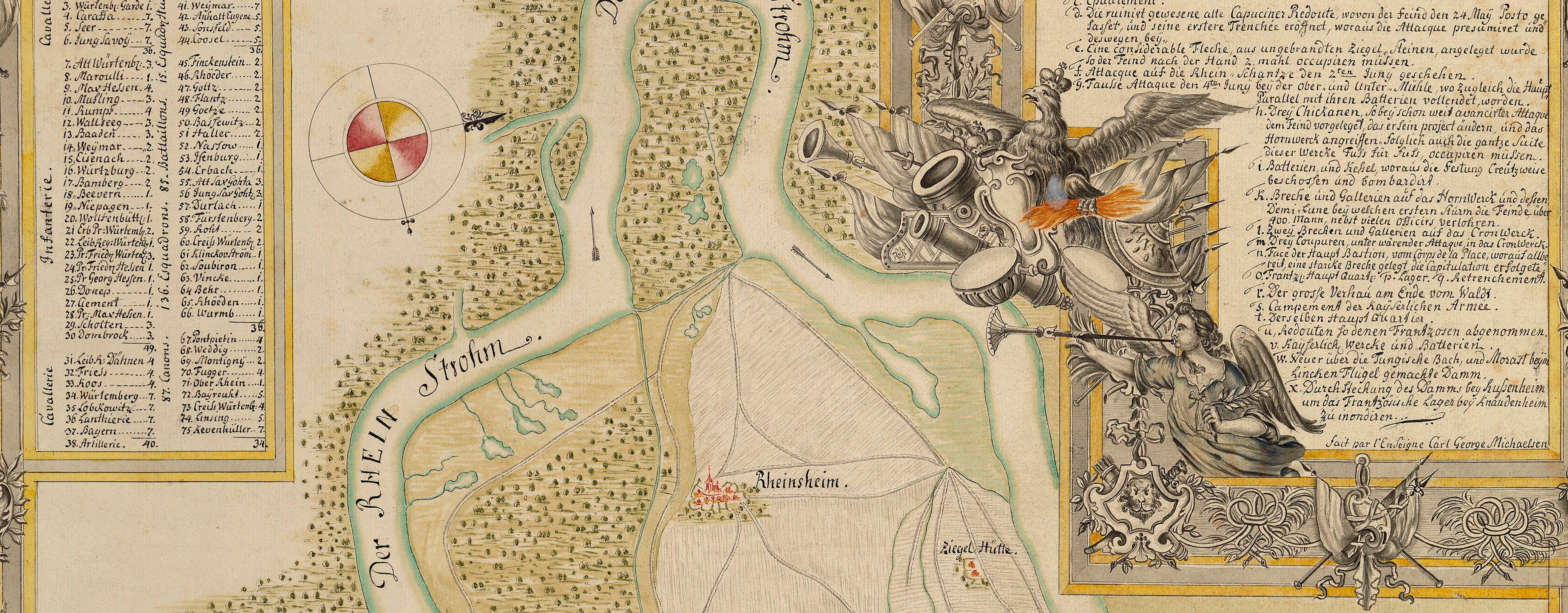
Map of the siege of Philippsburg, 1734 (Philippsburg, Baden-Württemberg, Germany) 49°13ʹ54ʺN 08°27ʹ39ʺE
1734 or laterPencil, pen, ink and watercolour on seven pieces of paper, previously joined; laid down on coarse linen | Scale: 1:19,200 approx. | RCIN 727049
This carefully drawn and beautifully embellished map shows in detail the topographical features of the landscape as well as the French camps, siege works and circumvallation surrounding Philippsburg. The positions of the Imperial army, commanded by Prince Eugène of Savoy (1663-1736), are shown to the east of the French lines. The Imperial army, which included Wilhelm I of Prussia and his son, later Frederick the Great, was unsuccessful in its attempts to lift the siege. Berwick, the commander of the French, was decapitated by a cannon ball before the siege ended.
Additional text: [top left, in rectangular panel, a key, 1-75, to the names of the cavalry and infantry regiments of the First and Second Lines of battle, of the Imperial army:] Nahmen der Kaÿserl: Regimtr: [top right, in irregularly-shaped panel, a key, a-i, k-x, to topographic and military features shown on the map:] Erklärung der Buchstaben.
Condition: one fold line; slight surface dirt; small tears to bottom edge. Verso: brown staining; foxing; heavy surface dirt.
Carl George Michaelsen (active 1734) (draughtsman) [top right, bottom right of of key:] fait par l’Enseigne Carl George Michaelsen.
Subject(s)
Army-FranceWatermark: Fleur-de-lys in crowned shield, a ‘4’ suspending the letters WR below; countermark: IV
Mark, stamped: 245
Condition: one fold line; slight surface dirt; small tears to bottom edge. Verso: brown staining; foxing; heavy surface dirt.
Scale: 1:19,200 approx. Scale bar: Maasse von 3000. Schritt, â Schr: Zu 2½ Frantz: Füss. [125 mm =] 3000.
77.2 x 62.4 cm (image and sheet)
62.4 x 51.1 cm (neatline)
Manuscript title:
CARTE von der Situation der Stadt und Festung PHILIPSBOURG, wie sothaner Orht / im Jahr 1734, den 23ten Maÿ von der Königlich Frantzösischen Armée belagert, und den 18ten Julÿ mit accord erobert, imgleichen wie in der Gegend Wiesenthal / die Röm: Kaÿserl: und Teutsche Reichs Armée, unter dem Commando des Printzen Eugenÿ von Savoyen campieret, vom 1ten biss den 22ten Julÿ obgedachten Jahres. [top]
Additional text:
[top left, in rectangular panel, a key, 1-75, to the names of the cavalry and infantry regiments of the First and Second Lines of battle, of the Imperial army:] Nahmen der Kaÿserl: Regimtr: [top right, in irregularly-shaped panel, a key, a-i, k-x, to topographic and military features shown on the map:] Erklärung der Buchstaben.
Annotations:
George III heading: On verso on white paper strip: Siege of Philipsbourg 23 May – 18 July 1734 and Encampment near Ditto 1-22 July 1734.
Other annotations: (Recto) none. (Verso) [bottom right, black pencil, illegible]; [right centre, red pencil, partly obscured by white paper strip:] [?] 49; [right centre, above old heading, black pencil, erased and illegible].
George III catalogue entry:
Philipsbourg Carte von der Situation der Stadt und Festung Philipsbourg wie sothaner orht im Jahr 1734 den 23 May von der Koniglich Frantzosishen Armée belagert, und den 18 July mit accord erobert, imgleichen wie in der gegend Wiesenthal die Rom. Kayserl. und Teutsche Reichs Armée unter dem commando des Printzen Eugenii von Savoyen campiret, vom 1 biss den 22 July obgedachten Jahres: von C.G. Michaelsen. drawn. [The same entry appears under the heading Encampment.]
Subject(s)
Philipsburg, Baden-Württemberg, Germany (49°13ʹ54ʺN 08°27ʹ39ʺE)


